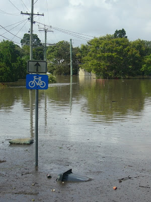
Over the past month Queensland has suffered massive floods and Victoria is now being inundated. As always happens when it rains, the bike paths were the first bit of transport infrastructure to go under. Guidelines advise a flood immunity immunity of 1 in 2 years for bike paths. This is most likely motivated by economic reasons rather than safety - but it is essential that safety be considered.
My local route to work is along a creek which doubles as a storm water drain. At some of the road underpasses it floods often. This is not too serious as there is a relatively simple and safe escape route/bypass that allows me to get past the flooded section.
The massive flood event like the one we just experienced has closed our major cycle routes into the city - not just for a few hours, but for weeks and some will be closed for months. The Bicentennial Bikeway is still closed a week after the floods. The floating walkway from New Farm to the Storey Bridge washed away and will take many months to replace. These routes are the active transport freeways into the city and carry around 10,000 pedestrians and cyclists a day. Where do these users go now that these routes are closed?
 Many of the trips made on these routes are for fitness and recreation and will just not be made. But what about those commuting trips that still need to be made? On the Monday after the floods I ventured in to work by bicycle to see how things work. Unlike my local route home along the creek the alternative routes for these major cycle routes into the city are far from obvious. Many cyclists would see the alternative routes as rather hazardous and would probably choose not to cycle. It will be interesting to interrogate the data from count stations after the floods (hopefully some are working) to see how the floods have impacted on commuter cycling.
I believe this shows that we are too reliant on our fantastic off-road cycle routes into the city. There is a need to bolster our on-road cycle routes which can act as alternative routes during flooding or construction. They need to allow cyclists to safely bypass the closed section and they need to be legible. The cycle lanes on Grey Street provide an excellent bypass of Southbank and the southern portion of the Bicentennial Bikeway, but people need help to navigate through the alternative route.
 Improved network legibility is not just about network resilience during unusual unplanned incidents (floods etc). It is vital during planned events that may close the normal route (festivals, construction, floods). Without this legibility the user (whether on a bicycle or on foot) is left wondering whether they should just risk wading through the flood waters because they see no alternative.
1 comment:
Interesting point about active traveling commuters - how best to travel? For my part, my regular routes were not available and I was forced to try alternative routes. Fortuitously, although six of Brisbane's seven bridges were isolated by water, the Storey Bridge remained available. I have never travelled actively over this bridge but now use it daily - it never occurred to me I would find it more direct and useful than my previous regular route. So perhaps active travelers, commuters and recreational, could try new paths? You never know your luck!
Post a Comment